 Subscribe
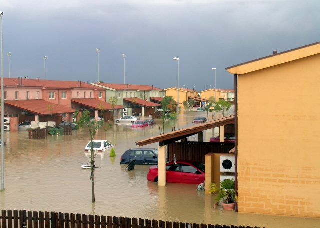
Italy, with its rich geological and morphological history, is an extremely vulnerable territory to a variety of natural disasters and it would be essential to prevent their effects.
Earthquakes, volcanic eruptions, floods and landslides are just some of the dangers that regularly threaten the country. As the climate crisis worsens, the need to monitor and manage these risks has become more urgent than ever. In this context, the “Hammon” project (Hazard mapping and vulnerability monitoring) was born, an ambitious and innovative initiative to create a multi-vulnerability mapping of the Italian territory.
The heart of the Hammon project is a supercomputer designed to analyze and integrate enormous amounts of data from different sources. The objective is to create a detailed and continuously updated photograph of the state of health of the Italian territory. The project is led by the National Centre for Research in High Performance Computing, Big Data and Quantum Computing (Icsc), with the important contribution of astronomer Ugo Becciani, leader of Spoke 3 of Icsc (Astrophysics & Cosmos Observations).
Becciani explains that the project uses technologies developed for astronomy, adapting them to study our planet. “We are applying downwards what we have always studied and created by looking upwards. We have the technologies needed to integrate enormous quantities of data arriving from many different sources and study multidimensional images”, says Becciani.
Hammon’s map is not limited to just one type of natural disaster. Instead, it integrates data on a wide range of risks, including earthquakes, volcanic eruptions, floods and landslides. The satellite images provided by the Cosmo-skymed and Prisma satellites of the Italian Space Agency (ASI) offer an overall view of the territory, while the drone and street view images allow specific areas and even individual buildings to be examined in more detail.
This detailed mapping allows you to evaluate the state of an area before and after a catastrophic event, helping to identify new damage and plan targeted interventions. For example, “street level” images document the condition of building facades and structures, allowing the detection of suspicious cracks or other signs of deterioration.
Hammon not only provides a snapshot of the present, but also tries to predict future risks. Using advanced algorithms, it processes meteorological, geological and seismic data to create detailed risk scenarios. These scenarios help Civil Protection and other relief agencies to identify the most vulnerable areas and plan preventive interventions.
The importance of this work was highlighted by the recent floods in Emilia Romagna in May 2023, which caused damage estimated at over €8.8 billion. Precise and integrated mapping of vulnerabilities could have helped mitigate the impact of this disaster, providing crucial information for relief and recovery operations.
A significant contribution to the Hammon project comes from the Unipol Group, which proposed the initiative to ICSC and is its leader. For an insurance company, a detailed vulnerability map is a valuable resource. It can improve policy pricing models, speed up the process of opening new policies and allow adjusters to inspect temporarily inaccessible areas. Additionally, it can help prevent scams by providing accurate documentation of property conditions before and after a catastrophic event.
The Hammon project is funded by the National Recovery and Resilience Plan until 2025, but its potential goes well beyond this deadline. Becciani is confident that the project will continue even after 2025, thanks to the strong internal alliances and stable relationships with the external bodies involved. “A project like this cannot fail to continue. It is clear that a fragile country like ours strongly needs it”, says Becciani.
The Hammon project represents a fundamental step forward in the management and prevention of natural disasters in Italy. By integrating data from a variety of sources and using advanced technologies, Hammon offers a detailed and continuously updated mapping of the vulnerabilities of the Italian territory. This initiative not only helps prevent and manage disasters, but also provides valuable tools for the insurance industry and for urban and environmental planning. In a country as vulnerable as Italy, projects like Hammon are essential to ensure the safety and resilience of local communities.